
For your inquiries , comments and to suggest a new set of data, please contact opendata@am.gov.ae
![]()
To read the map, please refresh the page by clicking on the refresh icon or (F5)
Then switch the side panel to choose the statement
![]()

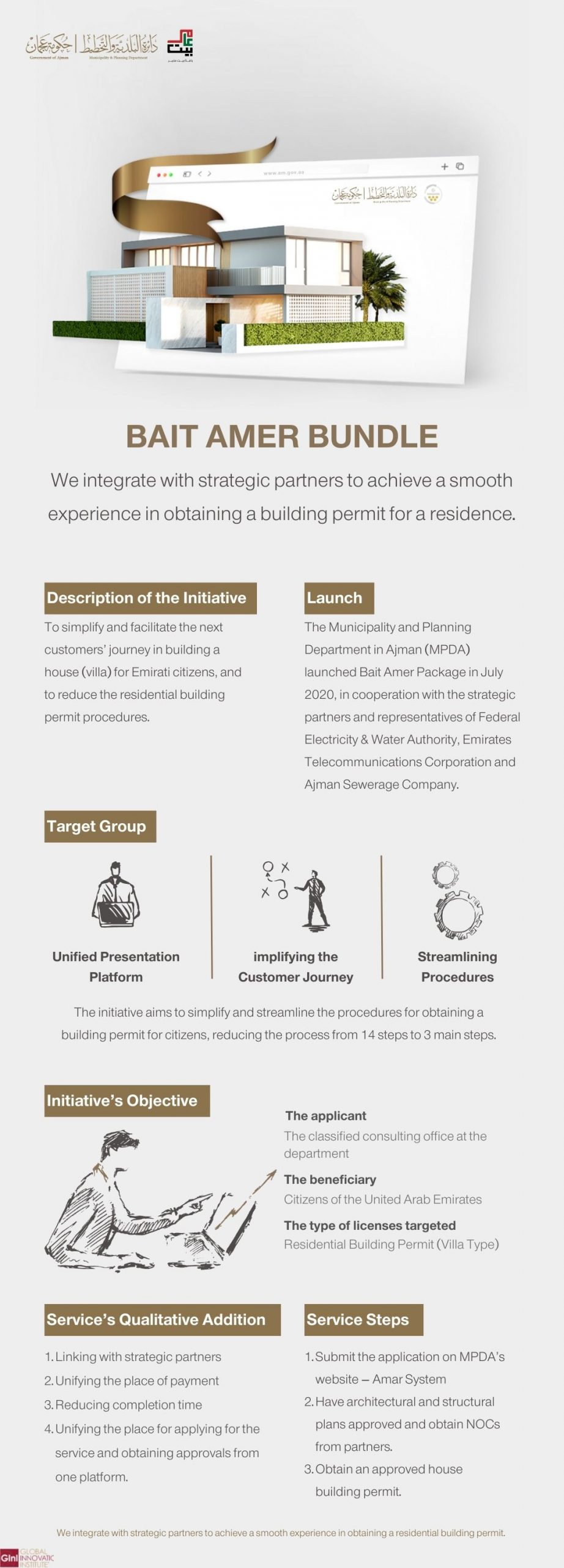
A government service that enables customers to obtain a permit to carry out maintenance works on an existing building.
Individuals – Corporates – Government Institutions
Individuals – Corporates – Government Institutions:1- Building owner ID card (individuals – Corporates)
2- Site plan
3- Maintenance contract between the owner and a general maintenance company
4- Architectural plans
5- Colour code or cladding sample in case of any changes in the external cladding
6- No- objection letter from the property owner to maintain (in case of tenant)
1.Submitting the request and attaching the required documents and paying fees via website
2.If the request is approved, the maintenance permit is issued.
3.If the request is rejected, customer will be notified via system
1- Website – Online Customer Happiness Services
2- Buildings Department
1000 AED
A service that enables customers to obtain a refund on the insurance fees paid for (building permits/maintenance permits/demolition permits/sunshades) after the project is completed.
Individuals – Corporates
Individuals:
1- Copy of the owner’s ID card
2- Permits (maintenance / sunshades / demolition)
3- Original insurance (customer’s payment receipt)
Corporates:
1- Copy of the owner’s ID card
2- Original insurance (customer’s payment receipt)
3- Permits (final certificate of completion / maintenance/ sunshade / demolition)
4- Bank account number of the corporation
1.Submitting the request and attaching the required documents
2.If the request is approved, request will be transferred to financial department for refunding via Bank account or via Cheque
3.If the request is rejected, customer will be notified via system
1- Website – Online Customer Happiness Services
2- Buildings Department
Free
This service enables customers to obtain To Whom It May Concern certificates addressed to specific entities.
Individuals – Corporates – Government Institutions
Individuals – Corporates – Government Institutions:
Request letter
Site plan issued from Ajman Municipality
1.Submitting the request and attaching the required documents and paying fees via website.
2.If the request is approved, the statement is issued.
3.If the request is rejected, customer will be notified via system.
1-Website – AMAR
2-MPDA mobile app
100 AED
An additional 50 AED will be added if a demolition certificate is requested
Government service that enables customers to request physical, chemical, and microbiological testing of food samples to verify their compliance with the approved standards. Such tests include the examination of imported and exported samples, food labels, promotional samples, and periodic samples.
Individuals – Corporates – Government Institutions
1- Sample testing request (Sample Receipt Form).
2- Food label to be examined for approval; in case of requesting Food label examination and assessment (corporates).
3- Sample testing request letter (government institutions).
1- Submitting the application through the website or through the Food and Environment Laboratory Department outlet.
2- It requires personal attendance to submit the sample in both cases (submission through the site or from the port).
3- Examination of samples in the laboratory.
4- Pay the fees and receive the report electronically.
1- Website – Public Health and Environment System
2- Food and environment laboratory outlet
Emiri Resolution No. (3) of 2018 regarding fees for public health services
Government service that enables customers to request environmental samples testing to verify their conformity with the approved standards. This include the examination of:
Seawater, organic fertilizers, lubricating oils, plastic bags, cosmetic products, factory waste, pool water, groundwater, and agricultural water .
Individuals – Corporates – Government Institutions
1- request for (Sample testing – environmental) at the Department of Food and Environment Laboratory.
2- Sample testing request letter (government institutions).
1- Submitting the application through the website or through the Food and Environment Laboratory Department outlet.
2- It requires personal attendance to submit the sample in both cases (submission through the site or from the port).
3- Examination of samples in the laboratory.
4- Pay the fees and receive the report electronically.
1- Website – Public Health and Environment System
2- Food and environment laboratory outlet
Emiri Resolution No. (3) of 2018 regarding fees for public health services
A government service that allows customers to renew a well drilling permit and utilize the water for agricultural, commercial, or household purposes.
Individuals – Corporates
1- Land title deed.
2- Authorization statement by the owner delegating the applicant to complete the request (if the applicant is not the owner) Copy of the owner’s passport Copy of the owner’s Emirates ID card.
1. Submitting the request through the website.
2. Paying the fees, Approving the request.
3. Receipt of the transaction via the website.
Website – Public Health and Environment System
Household purposes: AED 50 per well
Agricultural purposes: AED 100 per well
Commercial purposes: AED 10000
A government service that enables customers to pay environmental violation fees in accordance with the applicable procedures adopted via the Department’s MPDA electronic system.
Individuals – Corporates – Government Institutions
NA
1. Submitting the request via smartphone application MPDA
2. Paying the violation fees
3. Notifying the customer that the payment has been completed
MPDA phone app
As per the value of the issued violation
A government service that allows customers to obtain a well drilling permit that enables them to utilize the water for agricultural, commercial, or household purposes
Individuals – Corporates
1- Land title deed.
2- Authorization statement by the owner delegating the applicant to complete the request (if the applicant is not the owner) Copy of the owner’s passport Copy of the owner’s Emirates ID card.
1. Submitting the request through the website.
2. Paying the fees, Approving the request.
3. Receipt of the transaction via the website.
Website – Public Health and Environment System
Household purposes: AED 50 per well
Agricultural purposes: AED 100 per well
Commercial purposes: AED 10000
Commercial request submission fees: AED 2000
A government service that allows customers to renew their environmental permit that grants them initial or final approval on practicing environmental activities This includes industrial facilities, as well as facilities that engage in chemical trade, scrap trade and other activities that have an environmental impact. This service ensures that facilities comply with environmental requirements and guarantees the application and implementation of these environmental requirements.
Individuals – Corporates
Detailed internal layout of the activity requirements
1. Submitting the request through the website
2. Paying the fees, Approving the request
3. Receipt of the transaction via the website
Website – Public Health and Environment System
1- Environmental permit – slightly hazardous activities: AED 300
2- Environmental permit – moderately hazardous activities: AED 500
3- Environmental permit – highly hazardous activities: AED 1000
A government service that allows customers to obtain an environmental permit that grants them initial or final approval on practicing environmental activities This includes industrial facilities, as well as facilities that engage in chemical trade, scrap trade and other activities that have an environmental impact. This service ensures that facilities comply with environmental requirements and guarantees the application and implementation of these environmental requirements.
Individuals – Corporates
Detailed internal layout of the activity requirements
1. Submitting the request through the website
2. Paying the fees, Approving the request
3. Receipt of the transaction via the website
Website – Public Health and Environment System
1- Environmental permit – slightly hazardous activities: AED 300
2- Environmental permit – moderately hazardous activities: AED 500
3- Environmental permit – highly hazardous activities: AED 1000
This service allows facilities to issue official certificates indicating the facility’s commitment to environmental and public safety requirements as requested by local or federal government institutions in the country. The service is available under the (Compliance with Environmental and Safety Requirements) option. It provides customers with certificates tailored to their request and can be addressed to the concerned institution.
Individuals – Corporates
NA
1. Submitting the request through the website.
2. Paying the fees, Approving the request.
3. Receipt of the transaction via the website.
Website – Public Health and Environment System
AED 100
This service enables customers to terminate residential, investment or commercial contracts.
Individuals – Corporates – Government Institutions
Individuals:
Residential – Investment
– Letter signed by both parties (owner and tenant) terminating the contract
– Clearance from Ajman Sewerage
Corporates – Government Institutions:
Residential – Investment
– Letter signed by both parties (owner and tenant) terminating the contract
– Clearance from Ajman Sewerage
Commercial
– Letter signed by both parties (owner and tenant) terminating the contract
– Clearance from Ajman Sewerage
1. Submitting the request through the website
2. Processing the request within one business day
1- Website – Tasdeeq
2- MPDA mobile app
Free
Residential: A regulatory service aiming to preserve the rights of both parties (the owner and the tenant) in the Emirate under the applicable regulations and rules for the residence of families in residential units.
Investment: A regulatory service aiming to preserve the rights of both parties (the owner and the tenant) in the Emirate under the applicable regulations and rules for the investment of lands and properties.
Commercial: A regulatory service aiming to preserve the rights of both parties (the owner and the tenant) in the Emirate under the applicable regulations and rules for economic activities.
Individuals – Corporates – Government Institutions
Individuals:
Residential
– Authentication form
– Copy of the tenant’s passport
– Copy of the tenant’s ID card
– No-objection certificate from Ajman Sewerage
Investment
– Authentication form
– No-objection certificate from Ajman Sewerage
Corporates – Government Institutions:
Residential
– Authentication form
– Copy of the tenant’s passport (Corporates)
– Copy of the tenant’s ID card (Corporates)
– No-objection certificate from Ajman Sewerage
Investment
– Authentication form
– No-objection certificate from Ajman Sewerage
Commercial
– Authentication form
– No-objection certificate from Ajman Sewerage
1. Submitting the request through the website.
2. Examining the transaction and issuing approval within one business day.
3. Paying the service fees electronically.
Website – Tasdeeq
Authentication of Residential Contracts:
– (2%) of the lease value for a real estate unit according to the rental property calculator with a minimum fee of AED 400 (for non-nationals). National citizens are exempt from paying fees.
Authentication of Investment Contracts:
– (3%) of the annual lease value with a minimum of AED 1,000.
Authentication of Commercial Contracts:
– (5%) of the annual lease value with a minimum of AED 500.
– Sanitation fees as per activity.
A government service that allows customers to reserve a parking ticket for short or long periods through the mentioned channels.
Individuals
NA.
1.Submitting via MPDA application.
2. paying fees.
3. approving request (notifying the customer of the approval of ticket payment).
1- MPDA mobile app
2- SMS 5155
Half an hour: AED 1
One hour: AED 2
One and a half hours: AED 3
Two hours: AED 4
VIP ticket:
Half an hour: AED 3
One hour: AED 6
One and a half hours: AED 9
Two hours: AED 12
du / Etisalat Text Message: One hour: AED 2.38
VIP parking cards: 6000AED/ annually
2- 3000 AED per 6 months
3- 1500 AED per 3 months
PARKING cards for (people of determination) free
Parking cards for (senior Emirates )free
Parking cards (citizens ) building residents free
first card + second card (annually ) free
Parking cards Environment Friend per year free
Parking cards for Governmental institutions, local and Bank institutions
first card -:
1- annually 1200 AED
2- 600 AED per six months
3- 300 AED per 3 months
second card:
1- annually 600 AED
2- 300 AED PER 6 MONTHS
3- 150 AED per 3 months
This service enables customers to obtain a demolition permit for all building types.
Individuals – Corporates – Government Institutions
Individuals – Corporates – Government Institutions:1-No-objection letter from: Federal Electricity & Water Authority (FEWA)/ Rental Dispute Committee/ Etisalat- Emirates Telecommunications Corporation
2- Contract with the demolition company, owner, and consultant
3- Site plan
4- No-objection letter from the property owner to commence demolition works (Corporates – Government Institutions)
1.Submitting the request and attaching the required documents and paying fees via website
2.If the request is approved, the demolition permit is issued.
3.If the request is rejected, customer will be notified via system
1- Website – Online Customer Happiness Services
2- Buildings Department
1000 AED
Residential: A regulatory service aiming to preserve the rights of both parties (the owner and the tenant) in the Emirate under the applicable regulations and rules for the residence of families in residential units.
Investment: A regulatory service aiming to preserve the rights of both parties (the owner and the tenant) in the Emirate under the applicable regulations and rules for the investment of lands and properties.
Commercial: A regulatory service aiming to preserve the rights of both parties (the owner and the tenant) in the Emirate under the applicable regulations and rules for economic activities.
Individuals – Corporates – Government Institutions
Individuals:
Residential
– Authentication form
– Copy of the tenant’s passport
– Copy of the tenant’s ID card
– No-objection certificate from Ajman Sewerage
Investment
– Authentication form
– No-objection certificate from Ajman Sewerage
Corporates – Government Institutions:
Residential
– Authentication form
– Copy of the tenant’s passport (Corporates)
– Copy of the tenant’s ID card (Corporates)
– No-objection certificate from Ajman Sewerage
Investment
– Authentication form
– No-objection certificate from Ajman Sewerage
Commercial
– Authentication form
– No-objection certificate from Ajman Sewerage
Website – Tasdeeq
Authentication of Residential Contracts:
– (2%) of the lease value for a real estate unit according to the rental property calculator with a minimum fee of AED 400 (for non-nationals). National citizens are exempt from paying fees.
Authentication of Investment Contracts:
– (3%) of the annual lease value with a minimum of AED 1,000.
Authentication of Commercial Contracts:
– (5%) of the annual lease value with a minimum of AED 500.
– Sanitation fees as per activity.
This link will open data in a new tab.
A government service that enables customers to obtain a technical report that determines the status of existing or under construction buildings.
Individuals – Corporates – Government Institutions
Individuals – Corporates – Government Institutions:
Site plan
1.Submitting the request and attaching the required documents and paying fees via website.
2.If the request is approved, the report is issued.
3.If the request is rejected, customer will be notified via system.
Website – AMAR
1000 AED
A government service that allows customers to obtain a building permit for further construction on an existing building approved by the Department and in compliance with building specifications and requirements.
Corporates
1- Final architectural plans
2- Structural executive plans
3- Approved plans from relevant entities (if any): FEWA AND ETISALAT
4- Letter from the supervising consultant for buildings consisting of more than 20 floors (if applicable).
5- Approval for a New Contractor Project
1.Submitting the request and attaching the required documents and paying fees via website
2.If the request is approved, customer will receive permit
3.If the request is rejected, customer will be notified via system
Website – AMAR
1.Service provision fees for all buildings except for private residence: 500 AED
2.Fees for providing service for private/agricultural residential buildings: 50 AED
3.Building permit for a private residential / agricultural building: 3.5 AED / square meter, with a minimum of 200 AED
4.Building permit for all buildings (other than residential / agricultural): 6 AED / square meter, with a minimum of 200 AED
5.Permit to build a private/agricultural fence: 200 AED
6.Building permit for a private residential/agricultural annex: 200 AED
7.License for indoor/outdoor private residential/agricultural canopies: 200 AED
8.Permit for indoor/outdoor shades for all buildings (other than residential/agricultural): 500 AED
9.Insurance: 2 AED per square meter for all types of buildings, with a minimum of 500 AED for residential sheds, 1000 AED for annexes, 2,000 AED for residential villas, and 3000 AED for all types of buildings (other than residential / agricultural).
10.Technical report fee: 1000 AED
A service that allows customers to request a permit to use one or two lanes of a road for corporate projects in addition to setting up wedding or funeral tents.
Individuals – Corporates – Government Institutions
Individuals:1- UAE Identity 2. Aerial photograph of the site (via Google) and traffic transfer scheme
Corporates: 1- Project outline and traffic transfer scheme 2.Letter from the corporation
Government Institutions:1- Project outline and traffic transfer scheme 2- letter requesting from the institution.
1.Submitting the request at any of service channels
2. initial approval from road and infrastructure department
3. Paying service fees (there are no fees for wedding or funeral tents)
4. Receiving the permit
1- Website – Online Customer Happiness Services
2- Customer Happiness Center
AED 500 one lane per day
AED 1000 two lanes per day
AED 7000 one lane per month
AED 10,000 two lanes per month
A service that allows customers to issue a certificate addressed to official authorities stating all the properties owned by them in the Emirate of Ajman, whether it is a granted land or other types of properties. This certificate is required by the Sheikh Zayed Housing Programme, Social Affairs and other related institutions. The service is mostly targeted at individuals, and the only government institutions that request this service are Social Affairs or courts.
Individuals – Government Institutions
Individuals:
– Applicant’s original Emirati ID card
If the determination of inheritance certificate is completed:
– Power of attorney on behalf of the heirs or a letter from court
If the customer is granted power of attorney to act on behalf of other principals:
– Power of attorney from the applicant’s principals.
– Copy of Emirates ID card.
Government Institutions:
– Copies of Emirates ID cards of the persons for whom a certificate of owned properties is required
In the event of a dispute or if the heirs are underage and
determination of inheritance certificate is not issued:
– A letter from the court stating the inheritance
1- Apply for the service through the approved application channels
2- Fill out the application form
3- Request the required documents
4. Paying service fees (if any)
5. Issuing the certificate and delivering it to the customer
1- Website – Electronic Customer Happiness Services
2- Customer Happiness Center
Institutions exempted from fees:
– Ministry of Social Affairs
– Armed Forces
– Charitable bodies around the country
– Housing authorities and programmers
Institutions not exempted from fees, which are estimated at AED 100:
– Ministries and government departments
– Universities
– The Ruler’s Court
– To whom it may concern certificate without mentioning the institution
It is an e-service that allows citizens of the Emirate of Ajman to apply for a grant for a residential land or a government residence, provided that all the general and specific requirements are met.
Individuals
1-Personal photo of the beneficiary 2-Copy of a valid Emirates ID. 3-Copy of the passport. 4-Copy of the Family Book. 5-Copy of the marriage contract if the wife is not registered in the Family Book. 6- Statement of owned properties from the same Emirate where the applicant works if the place of work is outside the Emirate of Ajman (for married applicants). 7-Recent (original) detailed salary certificate from the employer or social affairs for both spouses, or a non-employment certificate from court if the applicant is unemployed. 8-Proof of residence (property deed, residential lease contract, or land plot plan). 9-Statement form for a land grant from the Department of Land and Real Estate Regulation (property) + archives (grants). 10-Statement from the Sheikh Zayed Housing Programme (for married + widowed + divorced applicants).
Additional documents required for divorced and widowed women:
1-Proof of marital status from court (proof of marriage termination + Custody certificate + alimony + proof of inability to provide residence for children if she has children (recent). 2-Copy of the family book of the (divorced / deceased) husband. 3-Copy of the children’s passports (for divorcees). 4-Determination of inheritance certificate (for widows) 5-Retirement certificate for the deceased husband (for widows).
Additional documents for women married to non-citizens:
1- Copy of the marriage contract. 2-Marriage continuity attestation certificate. 3- Copy of the passport of the husband and children with residency permits. 4-The husband’s salary certificate + employment contract + bank statements for the last 3 months. 5-Children’s birth certificate. 6-Certificate of commercial licenses for both spouses. 7-Education Continuity certificate for the children for a period of 3 years. Note: The committee has the right to request any other documents.
1. Submitting the request online.
2. Conducting a social study and an internal audit of the request and its attached documents within two business days
3. Forming a government housing and land plot grant committee
4. Responding to the request within 3 months
5. Issuing final approval and receiving the approved request from the system
Website – AMAR
Free
A service that allows customers to request setback termination (The area left empty on either the front or the back of the property, and once setback termination is approved then this area can be built on).
Individuals – Corporates – Government Institutions
Individuals – Corporates – Government Institutions:
1- Official authorization or power of attorney if the applicant is not the owner of the land.
2- Approval letter from the Planning and Survey Department- Planning Studies section.
3- -Determination of inheritance certificate from court if the applicant is one of the heirs (Individuals).
4- -Official letter from the requesting government institution addressed to the Head of the Planning Department. (Government Institutions)
1. Submitting the request through the website.
2. approving the request and Paying the fees.
3. Receiving the approved request from system
1-Website – AMAR
2-MPDA mobile app
5% of land price paid upon submitting the request × Gained floor area/ Total floor area permitted for the land before setting back.
A service that allows customers to add a full or partial floor depending on the number of floors permitted according to the building height system.
Individuals – Corporates – Government Institutions
Individuals – Corporates – Government Institutions:
1- Official authorization or power of attorney if the applicant is not the owner of the land.
2- Approval letter from the Planning and Survey Department- Planning Studies section.
3- -Determination of inheritance certificate from court if the applicant is one of the heirs (Individuals).
1. Submitting the request through the website.
2. approving the request and Paying the fees.
3. Receiving the approved request from system
1-Website – AMAR
2-MPDA mobile app
5% of land price paid upon submitting the request × Gained floor area/ Total floor area permitted for the land before addition
A service that allows customers to request a change in the land usage type (change the usage type to residential, commercial, or industrial usage)
Individuals – Corporates – Government Institutions
Individuals – Corporates – Government Institutions:
1- Official authorization or power of attorney if the applicant is not the owner of the land (Individuals – Corporates ).
2- Approval letter from the Planning and Survey Department- Planning Studies section.
3- -Determination of inheritance certificate from court if the applicant is one of the heirs (Individuals).
4- -Official letter from the requesting government institution addressed to the Head of the Planning Department. (Government Institutions)
1. Submitting the request through the website.
2. approving the request and Paying the fees.
3. Receiving the approved request from system
Website – AMAR
1% of land price paid upon submitting the request
A service that allows customers to request land sorting and partitioning (partitioning a land into two or more parts).
Individuals – Corporates – Government Institutions
1- Official authorization or power of attorney if the applicant is not the owner of the land (Individuals – Corporates ).
2- -Determination of inheritance certificate from court if the applicant is one of the heirs (Individuals).
3- -Official letter from the requesting government institution addressed to the Head of the Planning Department. (Government Institutions)
1. Submitting the request through the website.
2. approving the request and Paying the fees.
3. Receiving the approved request from system
1-Website – AMAR
2-MPDA mobile app
1 AED per square meter
This service enables customers to obtain accreditation for public health pest control companies ensuring the fulfillment of all the health requirements related to the service in order to maintain public health and safety in the Emirate.
Corporates
1- Public health pest control company accreditation file containing:
-List of pesticides used by the company in pest control operations along with its registration certificate at the Ministry of Climate Change and Environment
-Tools and equipment used by the company in pest control operations
-Certificate of a pest control specialized engineer working for the company as well as the owner’s ID documents
2- A written letter of commitment ensuring compliance with the requirements of federal and local laws
1. Submitting the request through the website
2. Paying the fees, Approving the request
3. Receipt of the transaction via the website
Website – Public Health and Environment System
AED 2000
A service that allows customers to request a permit to use one or two lanes of a road for corporate projects in addition to setting up wedding or funeral tents.
Individuals – Corporates – Government Institutions
Individuals:1- UAE Identity 2. Aerial photograph of the site (via Google) and traffic transfer scheme
Corporates: 1- Project outline and traffic transfer scheme 2.Letter from the corporation
Government Institutions:1- Project outline and traffic transfer scheme 2- letter requesting from the institution.
1.Submitting the request at any of service channels
2. initial approval from road and infrastructure department
3. Paying service fees (there are no fees for wedding or funeral tents)
4. Receiving the permit
1- Website – Online Customer Happiness Services
2- Customer Happiness Centre
AED 500 one lane per day
AED 1000 two lanes per day
AED 7000 one lane per month
AED 10,000 two lanes per month
A service that allows customers to request a permit for underground pipe works to connect service lines within the road reserve
Corporates – Government Institutions
Corporates: 1- site plan 2– Letter from the corporation
Government Institutions: 1- site plan 2- letter from Government institution
1.Submitting the request at any of service channels and paying the fees
2. processing the request
3. Receiving the permit
1- Website – Online Customer Happiness Services
2- Customer Happiness Centre
1110 AED
This service enables customers to obtain accreditation for public health pest control companies ensuring the fulfillment of all the health requirements related to the service in order to maintain public health and safety
in the Emirate.
Corporates
1- Public health pest control company accreditation file containing:
-List of pesticides used by the company in pest control operations along with its registration certificate at the Ministry of Climate Change and Environment
-Tools and equipment used by the company in pest control operations
-Certificate of a pest control specialized engineer working for the company as well as the owner’s ID documents
2- A written letter of commitment ensuring compliance with the requirements of federal and local laws
1. Submitting the request through the website
2. Paying the fees, Approving the request
3. Receipt of the transaction via the website
Website – Public Health and Environment System
AED 2000
A service that allows customers to request a permit to withdraw groundwater from excavation works by using a manhole or direct drainage to the sea.
Corporates
1- Building permit or certificate of no- objection.
2- Commercial license of the executing company issued by the Emirate of Ajman.
3-site plan.
4 – Groundwater drainage request letter from the customer.
5 – Copy of the follow-up card for extending a groundwater drainage pipe.
6 – In case of Request for a Drainage Permit for sea, a copy of Environmental management and Development department Accreditation to the Drainage Site.
7 – In Case of Request for Use of a Composite of Groundwater Withdrawal please add copy of Ownership of the tank from both sides is valid from the Emirate of Ajman.
8- In case of an application for permission for a dirt seater to collect water, a copy is added from the Department of Planning and survey approval of the plot of land on which the dirt seater will be executed..
1.Submitting the request at any of service channels and paying the fees.
2. initial approval from road and infrastructure department.
3. Paying service fees.
4. Receiving the permit.
1- Website – Online Customer Happiness Services
2-Roads and Infrastructure Department
Drainage in the sea: insurance fees AED 10,000 / Service fees AED 100 per day
Drainage in a manhole not connected to a pumping station: insurance fees AED 5,000 / Service fees AED 200 per day
Drainage in a manhole connected to a pumping station: insurance fees AED 30,000 / Service fees AED 500 for the pump per day
Collecting water inside an earthen berm: insurance fees AED 10,000
Using an existing pipe: Service fees AED 50 per day
PERMISSION TO VEHICLE FOR UNDERGROUNDWATER SUCTION (10,000 galloon) : insurance 10,000 AED – FEES : 4000 AED per month
A government service that allows customers to request an assessment of the damages caused by traffic accidents on road reserves of the Municipality & Planning Department.
Individuals – Corporates – Government Institutions
Copy of the Accident report.
1.Submitting the request at any of service channel.
2.Inspecting the site within three business days.
3.Contacting the customer via phone to notify him of the amount of the damage.
4.If the customer is insured, a letter will be issued with the amount of damage addressed to the insurance (via website ).
5.Paying the fees via website or via Customer Happiness Centre.
1- Website – Online Customer Happiness Services
2- Customer Happiness Centre
free (Value is determined based on the amount of damages caused by the accident)
This service provides a temporary contractor/consultant permit for Emirate of Ajman with the aim of adding a new project restricted to governmental or special projects.
Corporates
1-Temporary Permit Request Form (Contractor/ Consultant).
2- Copy of the project site plan.
3- Architectural plans for the proposed project.
4- An approved up-to-date list of employees.
5- A list of all implemented projects + certificates of completion.
6- Letter of assignment from the concerned authority.
1.Submitting the request and attaching the required documents.
2.If the request is approved, fees are paid, and the permit is issued.
3.If the request is rejected, customer will be notified via system.
1- Website – Online Customer Happiness Services
2- Customer Happiness Centre
Temporary permit fee 50,000 AED
The processing fee is 200 AED
This service allows for raising the ranking of a contractor / consultant after the fulfilment of the required qualifications for a higher ranking.
Corporates
Corporates: 1- Contractors and consultants classification service request form.
2- A list of all implemented projects + certificates of completion.
3- An approved up-to-date list of employees.
1.Submitting the request and attaching the required documents.
2.If the request is approved, fees are paid, and Raising the Ranking of a Contractor/Consultant is approved.
3.If the request is rejected, customer will be notified via system.
1- Website – Online Customer Happiness Services.
2- Customer Happiness Centre.
200 AED
A service that enables contracting companies and engineering consulting offices to submit a request to add a new project.
Corporates
Corporates:
1- Copy of the project site plan.
2- Copy of the project’s surveying table.
1.Submitting the request and attaching the required documents.
2.If the request is approved, fees are paid, and a New Consultant / Contractor Project is approved.
3.If the request is rejected, customer will be notified via system.
1- Website – Online Customer Happiness Services.
2- Customer Happiness Centre.
200 AED
This service provides approval to start practicing the profession of building contracting and engineering consulting after meeting the minimum required technical and administrative standards.
Corporates
Corporates: 1- Contractors and consultants classification service request form.
2- cards of society of Engineers.
3- A statement from the Department of Economic Development of the commercial licenses of the partners in the emirate.
4- Lease contract of the office.
5- Office plan with dimensions in m2.
6- An approved up-to-date list of employees.
1.Submitting the request and attaching the required documents.
2.If the request is approved, fees are paid, and Request for Professional Practice Accreditation (Contractor- Consultant) is approved.
3.If the request is rejected, customer will be notified via system.
1- Website – Online Customer Happiness Services.
2- Customer Happiness Centre.
AED 200
A government service that enables consultants to request an examination of building material samples such as aggregate tests, special tests, field density tests, soil and rock tests, block tests, concrete tests, iron tests, asphalt and asphalt mixture tests.
Individuals – Corporates – Government Institutions
Corporates – Government Institutions:.
1-Copy of the project’s approved building permit.
2- Copy of the project’s approved building permit (for the consultant approved by the government institution).
3- Material sample.
(Individuals) : Material sample.
1.Submitting the request and attaching the required documents and paying fees via website.
2. in case of external tests, field visit is determined.
3. in case of laboratory tests, samples have to be delivered to the lab.
4. test results will be sent via system upon required test (from 1 business day to 30 business days).
Website – AMAR
Annex to Resolution No. (9)/2018 regarding fees for services for the infrastructure development sector in Ajman Municipality and fines for violations related thereto.
This service provides exploratory on-site and well drilling surveys to determine the bearing capacity of the soil, specify the type of foundations best suited for the building, and then issue a certified geotechnical report of the results and recommendations.
Corporates – Government Institutions
Corporates – Government Institutions: 1- site plan issued from Ajman municipality.
1.Submitting the request and attaching the required documents and paying fees via website.
2.Scheduling a field visit date for commencing the testing process (subject to change depending on site readiness after completing the inspection).
3.Site inspection by the technician before commencing the testing process.
4.Analyzing the samples in the laboratory and determining the soil type.
5. receiving report from website.
1- Website – Online Customer Happiness Services
2-Building Materials Laboratory Outlet
Annex to Resolution No. (9)/2018 regarding fees for services for the infrastructure development sector in Ajman Municipality and fines for violations related thereto.
A government service that allows customers to request grading of dirt roads to facilitate their use for road users in residential areas in the Emirate.
Individuals
Site Plan or Makani Number.
1.Submitting the request at any of service channels.
2.Inspecting the site within three business days.
3.Approving the request and notifying the customer via phone.
1-Website – AMAR
2-Ajman Contact Centre 800701
Free
A government service that allows customers to request a permit to install a guiding sign on road reserve to locate sites and facilitate access.
Corporates – Government Institutions
Corporates – Government Institutions:
1-Letter from the concerned entity.
2-Road sign diagram.
3-Site plan of the road sign.
4- Applicant’s valid Emirates ID card.
1.Submitting the request at any of service channels
2.Inspecting the site within three business days
3.Approving the request and notifying the customer via phone
4. paying fees and Receiving the permit
1- Website – Online Customer Happiness Services.
2- Customer Happiness Centre.
AED 20,000 per year for a pole shaped road sign
AED 3,000 per year for one road sign
AED 7,000 per year for two road signs
AED 15,000 per year for three or more road signs
AED 10,000 per quarter for a pole shaped road sign
AED 1,000 per quarter for one road sign
AED 2,000 per quarter for two road signs
AED 5,000 per quarter for three or more road signs
(Government institutions are exempted from fees)
A government service that allows customers to request determining gate levels based on sea level.
Corporates
Corporates:
Copy of the site plan.
Copy of the identity of the applicant.
copy of Allocation of Sidewalks and Parking Lots approval (in case of commercial or industrial land).
1.Submitting the request at any of the available service channels.
2.Reviewing previous plans or conducting a new study on level plans.
3.Receiving the transaction within two business days.
1- Website – Online Customer Happiness Services.
2-Roads and Infrastructure Department.
Free
A government service that allows customers to request a permit to organize the works of sidewalks and parking lots within the limits of the road reserve.
Individuals – Corporates – Government Institutions
Individuals – Corporates – Government Institutions:
Copy of the site plan.
Copy of the license of the executing contractor.
Proposed sidewalk and parking lot work plans.
Permit form approved by the owner.
1.Submitting the request at any of service channels.
2.Reviewing the plan and issuing approval within one business day.
3.Receiving the follow- up card from Road Department.
4.Receiving the permit.
1- Website – Online Customer Happiness Services.
2-Roads and Infrastructure Department.
follow-up card fees:
– AED 500: for providing services to one or more streets with lengths ranging from 5,000 meters to 10,000 meters
– AED 10,000: for providing services to one or more streets with lengths over 10,000 meters
A government service that allows customers to request a permit to rent outdoor spaces within the road reserve
to be utilized for certain permitted activities that meet the conditions in place (for example: tents, outdoor seating areas for restaurants.
Individuals – Corporates
Individuals:
1- Land plan
2- Valid Emirates ID card
3- Images or illustrations of the required site
Corporates:
1- Valid commercial license
2- Lease contract
3- Valid Emirates ID card of the concerned person or a representative
4- Images or illustrations of the required site
1.Submitting the request at any of service channel
2.Inspecting the site within three business days
3.Approving the request and notifying the customer via phone
4. paying fees and Receiving the permit
Website – AMAR
AED 20 per month for using an area of a sidewalk on the main roads specified by the Department for coffee shops, cafeterias, or construction sites
AED 10 per month for using an area of a sidewalk on the secondary roads specified by the Department for coffee shops, cafeterias, or construction sites
AED 220 per year for using an area of a sidewalk on the main roads specified by the Department for coffee shops, cafeterias, or construction sites
AED 110 per year for using an area of a sidewalk on the secondary roads specified by the Department for coffee shops, cafeterias, or construction sites
AED 5 per month for using an area of a sidewalk for a seating area
AED 50 per year for using an area of a sidewalk for a seating area
A government service that allows customers to obtain no-objection certificates to commence construction work (excavation works within the road reserve).
Corporates – Government Institutions
Corporates – Government Institutions:
1- Letter from the entity issuing the request
2- Assignment order
3- Copy of the building permit
4- Copy of a valid contractor’s license issued from the Emirate of Ajman
5- Copy of the site plan and construction work plan
6- Plans approved by the owner (government institution)
1.Submitting the request at any of service channel
2. processing the request
3. sending payment permission via e-mail (follow-up card)
2.paying fees via MPDA application
5. Receiving follow- up card from The Road and Infrastructure Department.
6- Receiving the application from website
1- Website – Online Customer Happiness Services
2-Roads and Infrastructure Department
follow-up card fees: – AED 500: for providing services to one or more streets with lengths ranging from 5,000 meters to 10,000 meters
– AED 10,000: for providing services to one or more streets with lengths over 10,000 meters
A government service that allows customers to request a Clearance Certificate for the companies that obtained a No-Objection Certificate after completion of their assigned work processes.
Corporates – Government Institutions
Corporates – Government Institutions:
1- Original follow-up card
2- Copy of the site plan approved by the Department
3- Copy of the No-Objection Certificate
4- Letter from the owning entity stating that the contractor has completed work procedures
1.Submitting the request at any service channel.
2.processing the request.
3. approving request.
4.sending payment permission via e-mail.
5.paying fees via MPDA application.
6. Receiving follow- up card from The Road and Infrastructure Department.
7- Receiving the application from website.
1- Website – Online Customer Happiness Services.
2-Roads and Infrastructure Department.
follow-up card fees: AED 500: for providing services to one or more streets with lengths ranging from 5,000 meters to 10,000 meters
AED 10,000: for providing services to one or more streets with lengths over 10,000 meters
A government service that allows customers to request a Clearance Certificate for the companies that obtained a No-Objection Certificate after completion of their assigned work processes.
Corporates – Government Institutions
Corporates – Government Institutions:
1- Original follow-up card.
2- Copy of the site plan approved by the Department.
3- Copy of the No-Objection Certificate.
4- Letter from the owning entity stating that the contractor has completed work procedures.
1.Submitting the request at any service channel
2.processing the request
3. approving request
4.sending payment permission via e-mail
5.paying fees via MPDA application
6. Receiving follow- up card from The Road and Infrastructure Department.
7. Receiving the application from website
1- Website – Online Customer Happiness Services
2-Roads and Infrastructure Department
follow-up card fees: AED 500: for providing services to one or more streets with lengths ranging from 5,000 meters to 10,000 meters
AED 10,000: for providing services to one or more streets with lengths over 10,000 meters
A government service that allows customers to rent a fixed parking lot in front of commercial or private buildings.
Corporates – Government Institutions
Corporates:
Fixed Parking Lot Rental :
1- Copy of passport
2- Valid Emirates ID card
3- letter requesting rental parking from customer
4- Copy of a lease contract approved by concerned entities
5- Copy of the site plan
6- follow- up card
7- Makani number or image for the reserved parking
Governmental Institutions:
1 – An official letter from the government institution requesting the provision of fixed parking lots
1.Submitting the request at any service channel
2.Examining the submitted documents
3.Scheduling a site inspection date via phone
4.Notifying the customer of the approval or rejection via phone
5.Paying the fees at MPDA application and receiving the permit
6. installing the parking signage in front of commercial markets (new only)
1- Website – Online Customer Happiness Services
2- Customer Happiness Centre
AED 5,000 annually: for parking lots in dutiable sector districts/ (AED 2500 biannually)
AED 3,000 annually: for parking lots in non-dutiable sector districts/ (AED 1500 biannually)
AED 100: refundable parking rental plate insurance fees
AED 150: fixed parking transfer fees
A government service that allows customers to request the cancellation of a parking lot in front of commercial or private buildings to establish entrances and exits.
Corporates – Government Institutions
Corporates:
1- property ownership
2- Copy of passport
3- Valid Emirates ID card
4- no objection letter from the property owner
5- Copy of a lease contract approved by concerned entities
Governmental Institutions:
1- An official letter from the government institution requesting the cancellation of a parking lot
1.Submitting the request at any service channel.
2.Examining the submitted documents.
3.Notifying the customer of the approval or rejection via email.
4.Paying the fees at MPDA application and receiving the certificate.
1- Website – Online Customer Happiness Services
2- Customer Happiness Centre
AED 5,000: Parking lot cancellation fees in dutiable sector districts
AED 3,000: Parking lot cancellation fees in non-dutiable sector districts
A service that allows customers to consolidate two or more land plots. Customers receive an updated site plan if their request is approved.
Individuals – Corporates – Government Institutions
1- Official authorization or power of attorney if the applicant is not the owner of the land (Individuals – Corporates ).
2- -Determination of inheritance certificate from court if the applicant is one of the heirs (Individuals).
3- Official letter from the requesting government institution addressed to the Head of the Planning Department. (Government Institutions)
1. Submitting the request through the website.
2. approving the request and Paying the fees.
3. Receiving the approved request from system
Website – AMAR
Issuing Site Plan fees : AED 1000 for all uses
AED 500 for private residential uses
No fees for general services
No fees for Land Consolidation Request
A service that allows customers to issue a site plan for any land or area of land with detailed dimensions and an identifying number specified for construction.
Individuals – Corporates – Government Institutions
1- Official authorization or power of attorney if the applicant is not the owner of the land (Individuals – Corporates ).
2- -Determination of inheritance certificate from court if the applicant is one of the heirs (Individuals).
3- Official letter from the requesting government institution addressed to the Head of the Planning Department. (Government Institutions).
1. Submitting the request through the website.
2. approving the request and Paying the fees.
3. Receiving the approved request from system
1-Website – AMAR
2-MPDA mobile app
Issuing Site Plan fees : AED 1000 for all uses
AED 500 for private residential uses
No fees for general services
A government service that allows customers for Addressing and Numbering buildings, and it is divided into: requesting Makani Number, requesting house number, and requesting addressing building.
Individuals – Corporates – Government Institutions
1- copy of the site plan or title deed.
2- An official letter requesting the data (Corporates – Government Institutions).
1- submitting the application through the channel
2- Checking the transaction 3- accepting the application and Paying the fees 4-recirving the request .
1- Website – Customer Happiness Electronic Services.
2- Customer Happiness Centre.
One spatial data layer in CAD format for each area 100 AED
One spatial data layer in GIS format for each area100 AED
Satellite image data layer for each area 50 AED
An aerial image data layer for each area 100 AED
Issuing spatial address data 100 AED
Registration of one building for the first year 1000 AED
Registration of a group of buildings (complex) for the first year 2000 AED
This service enables customers to obtain accreditation for public health pest control companies ensuring the fulfillment of all the health requirements related to the service in order to maintain public health and safety in the Emirate.
Corporates
1- Public health pest control company accreditation file containing:
-List of pesticides used by the company in pest control operations along with its registration certificate at the Ministry of Climate Change and Environment
-Tools and equipment used by the company in pest control operations
-Certificate of a pest control specialized engineer working for the company as well as the owner’s ID documents
2- A written letter of commitment ensuring compliance with the requirements of federal and local laws
1. Submitting the request through the website
2. Paying the fees, Approving the request
3. Receipt of the transaction via the website
Website – Public Health and Environment System
AED 2000
This service enables customers to obtain accreditation for public health pest control companies ensuring the fulfillment of all the health requirements related to the service in order to maintain public health and safety in the Emirate.
Corporates
Letter explaining the amendments and data updates
1. Submitting the request through the website
2. Receipt of the transaction via the website
Website – Public Health and Environment System
Free
A government service that allows customers to request the issuance of spatial maps and plans to locate sites.
Corporates – Government Institutions
1- copy of the site plan or title deed.
2- An official letter requesting the issuance of spatial maps.
1- Submitting the application through the channel.
2- Checking the transaction.
3- Accepting the application and Paying the fees.
4-Recirving the request.
1- Website – Customer Happiness Electronic Services
2- Customer Happiness Centre
AED 100: Issuing and printing A3 plans
AED 500: Issuing and printing A0 plans
AED 250: Issuing and printing A1 plans
AED 30: Issuing and printing A4 plans
This is a free service that provides public health pest control services to homeowners (villas) in residential areas and government sites.
Corporates – Government Institutions
NA
1. Submitting the request through the website
2. Receipt of the transaction via the website
Website – Public Health and Environment System
Free
Residential – Investment – Commercial: This service allows customers to make amendments on approved contracts and change their data.
Individuals – Corporates – Government Institutions
Individuals:
Residential – Investment
– Letter signed by the property owner to amend the contract data
– Copy of the owner’s ID card
Corporates:
Residential – Investment – Commercial
– Letter signed by the property owner to amend the contract data
– Copy of the owner’s Emirates ID card
Government Institutions:
Residential – Investment – Commercial
– Letter signed by the property owner to amend the contract data
1. Submitting the request through the website.
2. Examining the transaction and issuing approval within one business day.
3- Handing over the updated contract to the customer.
1- Website – Online Customer Happiness Services.
2- Lease Regulation Department – Grand Mall.
Free.
A government service that enables customers to obtain accreditation on studies and reports concerned with environmental impact assessment, with the possibility of rejecting the study/report or requesting amendments.
Corporates
Hard or soft copy (USB) of the study
1- Opening an account on the department’s website or entering the digital identity account, submitting the application and attaching documents through the (Customer Happiness Services) platform.
2-Processing the order within 30 working days
3- Approving the transaction and paying the fees electronically
1- Website – Customer Happiness Electronic Services
2- Customer Happiness Center
AED 200
A government service that allows customers to conduct the required environmental measurements for the facility or institution, such as outdoor/indoor air quality, noise, lighting, or any other measurements.
Corporates
NA
1. Submitting the request through the website
2. Paying the fees, Approving the request
3. Receipt of the transaction via the website
Website – Public Health and Environment System
1- Environmental measurement fees (outdoor environment): AED 700
2- Environmental measurement fees (indoor environment per hour): AED 125
3- Dust measurement fees: AED 500
4- Noise measurement fees: AED 100
5- Electromagnetic wave measurement fees: AED 500
6- Fees for other measurements (other than the abovementioned measurements): AED 500
A government service provided upon the request of the customer to receive an environmental consultation regarding (facility sites / adding activities / waste treatment) to verify compliance with the required specifications and requirements in place in the Emirate.
Individuals – Corporates
NA
1. Submitting the request through the website
2. Paying the fees, Approving the request
3. Receipt of the transaction via the website
Website – Public Health and Environment System
AED 200
This service allows facilities to issue official certificates proving that the product is environmentally friendly as requested by local or federal government institutions in the country. The service is available under the (Environmentally friendly product) option. It provides customers with certificates tailored to their request and can be addressed to the concerned institution.
Individuals – Corporates – Government Institutions
NA
1. Submitting the request through the website
2. Paying the fees, Approving the request
3. Receipt of the transaction via the website
Website – Public Health and Environment System
AED 100
A service that enables customers to receive accreditation for environmental vehicles, which include vehicles used for transporting the following: (gas – scrap – cosmetics – non-potable water – chemicals and hazardous materials – diesel – collected waste – wastewater).
Corporates
Vehicle title
1. Submitting the request through the website
2. Paying the fees, Approving the request
3. Receipt of the transaction via the website
Website – Public Health and Environment System
AED 100 per vehicle
This service allows facilities to issue official certificates indicating the facility’s commitment to dispose of medical waste as requested by local or federal government institutions in the country. The service is available under the (Medical Waste Disposal Certificate of Commitment) option. It provides customers with certificates tailored to their request and can be addressed to the concerned institution.
Individuals – Corporates – Government Institutions
NA
1. Submitting the request through the website
2. Paying the fees, Approving the request
3. Receipt of the transaction via the website
Website – Public Health and Environment System
AED 100
A government service that enables customers to request an inspection of hazardous waste to determine the proper treatment and disposal mechanisms and methods.
Corporates
Material Safety Data Sheet
1. Submitting the request through the website
2. Paying the fees, Approving the request
3. Receipt of the transaction via the website
Website – Public Health and Environment System
AED 100
This service allows facilities to issue official certificates proving that materials are free of any environmentally harmful substances as requested by local or federal government institutions in the country. The service is available under the (Absence of Environmentally Harmful Substances) option. It provides customers with certificates tailored to their request and can be addressed to the concerned institution.
Individuals – Corporates
NA
1. Submitting the request through the website
2. Paying the fees, Approving the request
3. Receipt of the transaction via the website
Website – Public Health and Environment System
AED 100
A service that allows customers to buy yellow plastic bags and containers for sharp tools and medical waste
Corporates
NA
1. Submitting the request through the website
2. Paying the fees, Approving the request
3. Receipt of the transaction via the website
Website – Public Health and Environment System
1- Large yellow plastic bags – Value * Number: 1.50
2- Yellow container (5 liters) – Value * Quantity: 10
3- Yellow container (10 liters) – Value * Quantity: 15
4- Small yellow plastic bags – Value * Number: 1
5- Delivery of medical waste bags to the customer: 10
A government service that allows customers to register at the Department to start the process of collecting medical waste from medical facilities and treat them in designated medical waste incinerators
Corporates
NA
1. Submitting the request through the website
2. Paying the fees, Approving the request
3. Receipt of the transaction via the website
Website – Public Health and Environment System
AED 100
This certificate is issued to allow the entry of imported chemicals into the country while ensuring that proper approvals and authorizations from local authorities are obtained to guarantee public and environmental safety.
Corporates
1- Materials purchase receipt
2- Material Safety Data Sheet/ for each item
3- Permit of precursors if the Material is needed (by the Ministry of Health)
4- Chemicals import Permit if the Material is needed (by the Ministry of Interior)
1. Submitting the request through the website
2. Paying the fees, Approving the request
3. Receipt of the transaction via the website
Website – Public Health and Environment System
AED 200
This certificate is issued to allow the entry of imported chemicals into the country while ensuring that proper approvals and authorizations from local authorities are obtained to guarantee public and environmental safety.
Corporates – Government Institutions
NA
1. Submitting the request through the website
2. Paying the fees, Approving the request
3. Receipt of the transaction via the website
1-Website – AMAR
2-MPDA mobile app
500 AED
A service that enables customers to determine the ground level of land plots to set the amount of excavation.
Corporates – Government Institutions
NA
1. Submitting the request through the website
2. Paying the fees, Approving the request
3. Receipt of the transaction via the website
1-Website – AMAR
2-MPDA mobile app
1000 AED
A service that entails determining the height of the external fence before concrete casting.
Corporates – Government Institutions
NA
1. Submitting the request through the website
2. Paying the fees, Approving the request
3. Receipt of the transaction via the website
1-Website – AMAR
2-MPDA mobile app
500 AED
A service that entails determining the levels of ground bridges before concrete casting.
Corporates – Government Institutions
NA
1. Submitting the request through the website
2. Paying the fees, Approving the request
3. Receipt of the transaction via the website
1-Website – AMAR
2-MPDA mobile app
Free
A service that entails re-auditing and verifying the borders and boundaries of a land after excavation and installation of wooden and iron structures and before concrete casting.
Corporates – Government Institutions
NA
1. Submitting the request through the website
2. Paying the fees, Approving the request
3. Receipt of the transaction via the website
1-Website – AMAR
2-MPDA mobile app
Free
This service includes providing the land coordinates in an (XYZ) format.
Corporates – Government Institutions
Corporates – Government Institutions:
Site Plan
1. Submitting the request through the website
2. Paying the fees, Approving the request
3. Receipt of the transaction via the website
1-Website – AMAR
2-MPDA mobile app
300 AED per point
A regulatory service aiming to preserve the rights of both parties (the owner and the tenant) in the Emirate under the applicable regulations and rules for the residential compounds of staff, as well as provide staff residence permits.
Corporates
new, refurbished:
1- Attestation form.
2- Tenancy contract document for housing purposes in three copies.
3- A copy of the supervisor’s passport.
4- A copy of the Emirates ID card for both parties.
5- A copy of the property title deed and a copy of the power of attorney if the agent is present.
6- A copy of the completion certificate for the building ( Building Department).
7- No objection certificate from Ajman Sewerage Company.
8- No objection certificate from the General Command of Civil Defence.
9- Workers’ data from the company.
1- Submit the application through the channel.
2- Processing the request within one working day.
3- Pay the fee. 4 Receipt of the contract and a labour accommodation permit.
1- Website – Online Customer Happiness Services
2- Customer Happiness Centre
1- Staff Residential Contract: (5%) of the annual lease value with a minimum of AED 1,000
2- Staff residence permit AED 1,000
3- 50 AED per worker
This service includes providing the land coordinates in an (XYZ) format For cadastral reference points.
Corporates – Government Institutions
NA
1. Submitting the request through the website
2. Paying the fees, Approving the request
3. Receipt of the transaction via the website
Website – AMAR
1000 AED per point
This service allows customers to make amendments on approved residential contracts for workers and make updates on the data of these contracts.
Corporates
1- Two copies of the lease contract that requires amendment.
2- Letter signed by the property owner to amend the contract data.
3- Copy of the owner’s Emirates ID card.
1- Submitting the request through Channel.
2 – The procedure for the transaction and approval of the request within one working day.
3- Handing over the updated contract to the customer.
1- Website – Online Customer Happiness Services
2- Lease Regulation Department – Grand Mall
Free
A service that incudes determining the path of services (water – electricity – gas – telecom – irrigation) for trench-digging.
Corporates – Government Institutions
Corporates – Government Institutions:
Project plan
1. Submitting the request through the website
2. Paying the fees, Approving the request
3. Receipt of the transaction via the website
Website – AMAR
500 AED per point
A service that enables customers to register and license pet animals (dogs – cats) after undergoing veterinary examination and receiving the proper vaccinations to ensure public health and individual safety
Individuals
1- Vaccination record
2- Lease/ownership contract of the residence location
3- Pet picture
4- Pet ownership certificate: Purchase bill if the pet is purchased, or importation permit
1. Submitting the request through the website
2. Paying the fees, Approving the request
3. Receipt of the transaction via the website
Website – Public Health and Environment System
Pet animal licensing – dog: AED 150
Pet animal licensing – cat: AED 50
A service that enables customers to terminate the authentication of workers residential contracts.
Corporates
1- A letter signed by both parties (the lessor and the tenant) cancelling the contract.
2- The lease contract to be cancelled (two copies).
3- Clearance from Ajman Sewerage Company.
1- Submitting the application through the specified channel.
2- Checking the documents.
3- Processing the request within one working day.
4- Receipt of a copy of the cancelled contract and the contract cancellation certificate.
1- Website – Online Customer Happiness Services
2- Lease Regulation Department – Grand Mall
AED 100
A service that enables customers to register and license pet animals (dogs – cats) after undergoing veterinary examination and receiving the proper vaccinations to ensure public health and individual safety
Individuals
1- Number of the previous license
2- Vaccination record
3- Lease/ownership contract of the residence location
4- Pet picture
5- Pet ownership certificate: Purchase bill if the pet is purchased, or importation permit
1. Submitting the request through the website
2. Paying the fees, Approving the request
3. Receipt of the transaction via the website
Website – Public Health and Environment System
Pet animal licensing – dog: AED 150
Pet animal licensing – cat: AED 50
A government service that allows customers to request a site cleanliness certificate after the completion of construction work to ensure that there are no violations or notes in order to receive a refund on the insurance fees paid in advance to obtain building permit
Individuals – Corporates
1- Official letter requesting a site cleanliness certificate
2- Certificate of completion
3- Insurance receipt
1. Submitting the request through the website
2. Paying the fees, Approving the request
3. Receipt of the transaction via the website
Website – Public Health and Environment System
AED 100
A regulatory service aiming to preserve the rights of both parties (the owner and the tenant) in the Emirate under the applicable regulations and rules for the residential compounds of workers, as well as provide workers residence permits.
Corporates
new, refurbished:
1- Attestation form.
2- Tenancy contract document for housing purposes in three copies.
3- A copy of the Emirates ID card for both parties.
4- A copy of the property title deed and a copy of the power of attorney if the agent is present.
5- A copy of the completion certificate for the building ( Building Department).
6- No objection certificate from Ajman Sewerage Company.
7- Staff ’s data from the company.
1- Submit the application through the channel.
2- Processing the request within one working day.
3- Pay the fee.
4- Receipt of the contract and a staff accommodation permit.
1- Website – Online Customer Happiness Services
2- Customer Happiness Centre
1- Workers Residential Contract: (5%) of the annual lease value with a minimum of AED 1,000
2- Workers residence permit AED 1,000
A government service that allows customers or the public to request waste containers in front of their houses and buildings
Individuals – Corporates – Government Institutions
Individuals:
– Customer’s contact number or Makani number
Corporates:
– Commercial license
Government Institutions:
– Official letter from the concerned institutions
1. Submitting the request through the mentioned service delivery channels
2. Approving the request (receiving a text message)
Website – Public Health and Environment System
Ajman Contact Center 80070
Free
A government service that allows customers or the public to request the transfer of household waste
Individuals
NA
1. Submitting the request through the mentioned service delivery channels
2. Approving the request (receiving a text message)
Website – Public Health and Environment System
Ajman Contact Center 80070
Free
This service allows customers to make amendments on approved staff residential contracts and make updates on the data of these contracts.
Corporates
1- Two copies of the lease contract that requires amendment.
2- Letter signed by the property owner to amend the contract data.
3- Copy of the owner’s Emirates ID card.
1- Submitting the request through Channel.
2 – The procedure for the transaction and approval of the request within one working day.
3- Handing over the updated contract to the customer.
1- Website – Online Customer Happiness Services
2- Lease Regulation Department – Grand Mall
Free
This service enables customers to obtain the technical approvals required for the licenses and permits of vehicles intended to be used in food and health activities in the Emirate to ensure their compliance with the applicable regulations and laws and protect public health.
Corporates
1- Ownership details of the vehicle requested to be licensed
2- Distributors’ occupational health cards
3- Cooling and freezing vehicle calibration certificates
4- Food distributors’ training certificates
1. Submitting the request through the website
2. Paying the fees, Approving the request
3. Receipt of the transaction via the website
Website – Public Health and Environment System
AED 100
A government service that allows the customer to inquire about impounded private vehicles that were left behind and neglected across various facilities around the Emirate and request their recovery after payment of fees.
Individuals – Corporates – Government Institutions
Individuals – Corporates – Government Institutions
1- Copy of the owner’s Emirates ID
2- Copy of vehicle ownership, papers of vehicle possession or export, or vehicle data from the Traffic Services and Licensing Center.
3- Copy of the commercial or industrial license for all U Emirates of the country (Corporates)
4- Official authorization letter from the company to the Municipality & Planning Department (Corporates – Government Institutions)
1. Submitting the request form online
2. Submitting a request to release impounded vehicles
3. Paying service fees
4. Receiving a notification through the system regarding the approval of the request
Website – Public Health and Environment System
AED 300 vehicle release charges
AED 100 light vehicle transportation charges
AED 600 heavy vehicle transportation charges
AED 200 boat transportation charges
AED 1,000 caravan transportation charges
AED 1,000 prefabricated house transportation charges
AED 500 as a fine for putting vehicles up for sale
AED 15 (per day) administrative, demurrage and guarding charges
A service that enables customers to terminate the authentication of staff residential contracts.
Corporates
1- A letter signed by both parties (the lessor and the tenant) cancelling the contract.
2- The lease contract to be cancelled (two copies).
3- Clearance from Ajman Sewerage Company.
1- Submitting the application through the specified channel.
2- Checking the documents.
3- Processing the request within one working day.
4- Receipt of a copy of the cancelled contract and the contract cancellation certificate.
1- Website – Online Customer Happiness Services
2- Lease Regulation Department – Grand Mall
AED 100
An annual investment contract that allows the beneficiary to use the leased land to carry out an activity at a fixed and agreed upon rate between the investor and the Department.
Individuals – Corporates
Individuals – Corporates
1- Request for a land rental 2- No-objection letter approved by His Highness the Chairman of the Department 3- valid ID card 4- valid passport (for residents) 5- Site building design
1. Submitting the request form with a study on the project through one of the service delivery channels
2. Processing the request, issuing approval or rejection within 5 business days and notifying the customer
3.Ratifying a contract (constitutive contract) or a permit between the two parties Set all requirements for rent value and lease years for legal affairs to review and approve the contract
4. Pay the due rent and hand over to the tenant a copy of the receipt voucher and the lease contract or permit.,
5. Handing over the specified site to the lessee by the Investments Department
1-Investments Department
2-Email: invest@am.gov.ae
3-website
Apply for the service: Free
Upon attestation of the contract – rental contract attestation service fees apply
A service that enables customers to authenticate lease complaints submitted by the owner or the tenant in the event of a dispute between the two parties, in order for a judicial ruling to be issued by the Rental Dispute Resolution Committee.
Individuals – Corporates – Government Institutions
Individuals – Corporates – Government Institutions
1- Letter from the Rental Dispute Committee
2- Three copies of the lease contract
3- Copy of the complainant’s ID card
4- Copy of the property owner’s title deed if the complainant owns the property with a copy of the power of attorney in case thereof
5- Copy of a previous certified contract or proof of lease agreement
6- No-objection certificate from Ajman Sewerage
7- Copy of the Emiri Decree establishing the institution (Government Institutions)
1- Submitting the application through the channel.
2- Checking the transaction.
3- Paying the fees.
4- Accepting and contracting the certified contract within one working day.
1-Website – Online Customer Happiness Services
2-Lease Regulation Department – Grand Mall
1- Residential Contract: (2%) of the annual lease value with a minimum of AED 400
2- Investment Contract: (3%) of the annual lease value with a minimum of AED 1,000
3- Commercial Contract: (5%) of the annual lease value with a minimum of AED 500 in addition to sanitation fees
4- Workers-Staff Residential Contract: (5%) of the annual lease value with a minimum of AED 1,000
An annual investment contract that allows the beneficiary to use the Emirate’s lighting poles, central islands, and roadsides for installing advertising billboards at a fixed rate specified within the advertising billboard fee table.
Individuals – Corporates
Individuals – Corporates
1- Request to rent spaces from the advertising company 2- valid ID card 3- valid passport (for residents) 4- A list of sites for rent against the type of billboard and pictures of the sites, 5- If the billboard is on the roofs of buildings, attach a letter from the consultant with the approval of (Buildings Department)
1. Submitting the request form with a study on the project through one of the service delivery channels
2. Processing the request, issuing approval or rejection within 5 business days and notifying the customer
3.Ratifying a contract (constitutive contract) or a permit between the two parties Set all requirements for rent value and lease years for legal affairs to review and approve the contract
4. Pay the due rent and hand over to the tenant a copy of the receipt voucher and the lease contract or permit.,
5. Handing over the specified site to the lessee by the Investments Department
1-Investments Department
2-Email: invest@am.gov.ae
3-website
Apply for the service: Free
Upon attestation of the contract – rental contract attestation service fees apply
The process of crushing, breaking and aggregation of rocks to be used in building materials by a specialized company.
Individuals – Corporates
Individuals – Corporates
1- Crushing license request letter 2- Valid ID card 3- Valid passport (for residents) 4- Aerial photograph and site plan
1. Submitting the request form with a study on the project through one of the service delivery channels
2. Processing the request, issuing approval or rejection within 5 business days and notifying the customer
3.Ratifying a contract (constitutive contract) or a permit between the two parties Set all requirements for rent value and lease years for legal affairs to review and approve the contract
4. Pay the due rent and hand over to the tenant a copy of the receipt voucher and the lease contract or permit.,
5. Handing over the specified site to the lessee by the Investments Department
1-Investments Department
2-Email: invest@am.gov.ae
3-website
Apply for the service: Free
Upon attestation of the contract – rental contract attestation service fees apply
An annual investment contract enabling the beneficiary to use the rented premises to practice a commercial activity at a set value specified in the contact concluded between both parties.
Individuals – Corporates
Individuals – Corporates
1- Request letter from the lessee 2- Valid ID card 3- Valid passport (for residents)
1. Submitting the request form with a study on the project through one of the service delivery channels
2. Processing the request, issuing approval or rejection within 5 business days and notifying the customer
3.Ratifying a contract (constitutive contract) or a permit between the two parties Set all requirements for rent value and lease years for legal affairs to review and approve the contract
4. Pay the due rent and hand over to the tenant a copy of the receipt voucher and the lease contract or permit.,
5. Handing over the specified site to the lessee by the Investments Department
1-Investments Department
2-Email: invest@am.gov.ae
3-website
Apply for the service: Free
Upon attestation of the contract – rental contract attestation service fees apply
It is a permit to rent vacant spaces in parks for investors to hold their own seasonal events and activities, event sites, car wash sites, smart device sites and other sites, according to a specific value between the department and the investor.
Individuals – Corporates
Individuals – Corporates
1- Request letter from the lessee 2- Valid ID card 3- Valid passport (for residents)
1. Submitting the request form with a study on the project through one of the service delivery channels
2. Processing the request, issuing approval or rejection within 5 business days and notifying the customer
3.Ratifying a contract (constitutive contract) or a permit between the two parties Set all requirements for rent value and lease years for legal affairs to review and approve the contract
4. Pay the due rent and hand over to the tenant a copy of the receipt voucher and the lease contract or permit.,
5. Handing over the specified site to the lessee by the Investments Department
1-Investments Department
2-Email: invest@am.gov.ae
3-website
Apply for the service: Free
Upon attestation of the contract – rental contract attestation service fees apply
This service enables any user registered on the e-service system to add the properties they own or represent to their account in order to be available at a later time for any lease contract request services.
Individuals – Corporates – Government Institutions
Individuals – Corporates – Government Institutions
1- Copy of title deed and a Copy of the power of attorney in case thereof
2- Copy of land plan and completion certificate
3- Copy of passport
4- Copy of ID card
5- Copy of the Emiri Decree establishing the institution (Government Institutions)
1. Submitting the request through the website.
2. Examining the request and issuing approval within one business day.
Website – Tasdeeq
Free
A consulting service to inspect investors’ new sites
in order to issue the initial approval for licensing food and health activities before starting economic licensing procedures.
Individuals – Corporates
1- Details of the site requested to be inspected (Makani number – site / warehouse number)
2- Details of the activity requested to be licensed
1. Submitting the request through the website
2. Paying the fees, Approving the request
3. Receipt of the transaction via the website
Website – Public Health and Environment System
AED 200
This service allows customer to obtain accreditation certificates for food facilities to hold Mass Iftar during Ramadan and to ensure the safety of the food provided to consumers during the holy month.
Corporates
1- APHP accreditation certificate for the facility
2- Details of meal transport and distribution vehicles
3- Number and occupational health cards of the facility staff
1. Submitting the request through the website
2. Paying the fees, Approving the request
3. Receipt of the transaction via the website
Website – Public Health and Environment System
AED 500
A service that enables customers to obtain all initial approvals required for the licenses and permits of food and health activities of food facilities in the Emirate to ensure that all activity requirements are met before starting the activity.
Corporates
1- Economic permit request (Initial approval of the Department of Economic Development)
2- Lease / ownership contract
3- Detailed internal layout of activity requirements from a company approved by the Department
1. Submitting the request through the website
2. Paying the fees, Approving the request
3. Receipt of the transaction via the website
Website – Public Health and Environment System
AED 200: Inspection fees for food or health facility – limited activities (license / renewal)
AED 500: Inspection fees for food or health facility – medium-scale activities (license / renewal)
AED 1,000: Inspection fees for food or health facility – large-scale activities (license / renewal
A service that enables customers to renew initial approvals required for the licenses and permits of food and health activities of food facilities in the Emirate to ensure that all activity requirements are met before starting the activity.
Corporates
1- Economic permit request (Initial approval of the Department of Economic Development)
2- Lease / ownership contract
3- Detailed internal layout of activity requirements from a company approved by the Department
1. Submitting the request through the website
2. Paying the fees, Approving the request
3. Receipt of the transaction via the website
Website – Public Health and Environment System
AED 200: Inspection fees for food or health facility – limited activities (license / renewal)
AED 500: Inspection fees for food or health facility – medium-scale activities (license / renewal)
AED 1,000: Inspection fees for food or health facility – large-scale activities (license / renewal
A service that enables customers to issue different official certificates or letters to UAE government entities as per their request. This service is provided to companies in the Emirate of Ajman only.
Corporates
Details of the entity for which the certificate is required or any attachment proving that
1. Submitting the request through the website
2. Paying the fees, Approving the request
3. Receipt of the transaction via the website
Website – Public Health and Environment System
AED 100
A service that enables customers to obtain accreditation of health supervision staff in food and health facilities in the Emirate to ensure their effective implementation of food and public health safety management systems.
Corporates
1- Health supervisor’s details (academic qualifications – experience and training certificates in the field of food and public health)
2- Training certificate from Ajman Public Health Program (APHP)
3- The supervisor’s occupational health card
1. Submitting the request through the website
2. Paying the fees, Approving the request
3. Receipt of the transaction via the website
Website – Public Health and Environment System
AED 500
A service that enables customers to renew accreditation of health supervision staff in food and health facilities in the Emirate to ensure their effective implementation of food and public health safety management systems.
Corporates
1- Health supervisor’s details (academic qualifications – experience and training certificates in the field of food and public health)
2- Training certificate from Ajman Public Health Program (APHP)
3- The supervisor’s occupational health card
1. Submitting the request through the website
2. Paying the fees, Approving the request
3. Receipt of the transaction via the website
Website – Public Health and Environment System
AED 500
This service allows customers to obtain a night work permit for implementing building and construction works at night during specific hours of the evening for a specified time period. The permit is given after receiving the supervisor’s approval on the site’s terms and conditions.
Corporates
Corporates: 1- copy of building permit
1.Submitting the request and attaching the required documents.
2.If the request is approved, fees are paid, and the permit is issued.
3.If the request is rejected, customer will be notified via system.
1- Website – Online Customer Happiness Services
2- Buildings Department
500 AED
A service that enables customers to obtain accreditation of food safety management system certification companies and auditors in the Emirate to ensure the quality and reliability of such public health supporting companies.
Corporates
1- From outside the Emirate: Company accreditation certificates from the municipality it is affiliated to and the type of accreditation
2- Service providers’ specialized certificates as per the type of service accreditation
3- Service providers’ ID documents proving their employment at the company
4- Auditors’ APHP accreditation certificates
1. Submitting the request through the website
2. Paying the fees, Approving the request
3. Receipt of the transaction via the website
Website – Public Health and Environment System
AED 3000
A service that enables customers to obtain accreditation of food safety and public health consultancy companies and their consultants in the Emirate to ensure the quality and reliability of such public health supporting companies.
Corporates
1- From outside the Emirate: Company accreditation certificates from the municipality it is affiliated to and the type of accreditation
2- Service providers’ specialized certificates as per the type of service accreditation
3- Service providers’ ID documents proving their employment at the company
4- Auditors’ APHP accreditation certificates
1. Submitting the request through the website
2. Paying the fees, Approving the request
3. Receipt of the transaction via the website
Website – Public Health and Environment System
AED 3000
A service that enables customers to obtain accreditation of food safety management systems training companies and trainers in the Emirate to ensure the quality and reliability of such public health supporting companies.
Corporates
1- From outside the Emirate: Company accreditation certificates from the municipality it is affiliated to and the type of accreditation
2- Service providers’ specialized certificates as per the type of service accreditation
3- Service providers’ ID documents proving their employment at the company
4- Auditors’ APHP accreditation certificates
1. Submitting the request through the website
2. Paying the fees, Approving the request
3. Receipt of the transaction via the website
Website – Public Health and Environment System
AED 3000
A service that enables customers to obtain accreditation of food analysis laboratories in the Emirate to ensure the quality and reliability of such public health supporting companies.
Corporates
1- From outside the Emirate: Company accreditation certificates from the municipality it is affiliated to and the type of accreditation
2- ISO 17025 laboratory certification from the approved authorities in the country
3- A written undertaking by the company to report all improper results to the Department in order to take the necessary actions
1. Submitting the request through the website
2. Paying the fees, Approving the request
3. Receipt of the transaction via the website
Website – Public Health and Environment System
AED 3000
A service that enables customers to obtain accreditation of drinking water tank cleaning and purifying companies in the Emirate to ensure the quality and reliability of such public health supporting companies.
Corporates
1- From outside the Emirate: Company accreditation certificates from the municipality it is affiliated to and the type of accreditation
2- Service providers’ specialized certificates as per the type of service accreditation
3- Service providers’ ID documents proving their employment at the company
4- Chemical details
5- Diagram of the cleaning and purification process
1. Submitting the request through the website
2. Paying the fees, Approving the request
3. Receipt of the transaction via the website
Website – Public Health and Environment System
AED 3000
A service that enables customers to obtain accreditation for food and health facility plan designing companies in the Emirate to ensure the quality and reliability of such public health supporting companies.
Corporates
1- From outside the Emirate: Company accreditation certificates from the municipality it is affiliated to and the type of accreditation
2- Service providers’ specialized certificates as per the type of service accreditation
3- Service providers’ ID documents proving their employment at the company
4- – Copies of plans executed by the company (11 activities)
1. Submitting the request through the website
2. Paying the fees, Approving the request
3. Receipt of the transaction via the website
Website – Public Health and Environment System
AED 3000
A service that enables customers to obtain accreditation for school and nursery food suppliers to ensure the safety of the food provided to this sensitive group of society and to preserve public health.
Corporates
1- Facility APHP accreditation certificate
2- Details of meal transport and distribution vehicles
3- List of supplied food items
4- From outside the Emirate: Letter explaining the health status of the facility issued by the concerned municipality
1. Submitting the request through the website
2. Paying the fees, Approving the request
3. Receipt of the transaction via the website
Website – Public Health and Environment System
AED 500
A service that enables customers to renew accreditation of food safety management system certification companies and auditors in the Emirate to ensure the quality and reliability of such public health supporting companies.
Corporates
1- From outside the Emirate: Company accreditation certificates from the municipality it is affiliated to and the type of accreditation
2- Service providers’ specialized certificates as per the type of service accreditation
3- Service providers’ ID documents proving their employment at the company
4- Auditors’ APHP accreditation certificates
1. Submitting the request through the website
2. Paying the fees, Approving the request
3. Receipt of the transaction via the website
Website – Public Health and Environment System
AED 3000
A service that enables customers to renew accreditation of food safety and public health consultancy companies and their consultants in the Emirate to ensure the quality and reliability of such public health supporting companies.
Corporates
1- From outside the Emirate: Company accreditation certificates from the municipality it is affiliated to and the type of accreditation
2- Service providers’ specialized certificates as per the type of service accreditation
3- Service providers’ ID documents proving their employment at the company
4- Auditors’ APHP accreditation certificates
1. Submitting the request through the website
2. Paying the fees, Approving the request
3. Receipt of the transaction via the website
Website – Public Health and Environment System
AED 3000
A service that enables customers to renew accreditation of food analysis laboratories in the Emirate to ensure the quality and reliability of such public health supporting companies.
Corporates
1- From outside the Emirate: Company accreditation certificates from the municipality it is affiliated to and the type of accreditation
2- ISO 17025 laboratory certification from the approved authorities in the country
3- A written undertaking by the company to report all improper results to the Department in order to take the necessary actions
1. Submitting the request through the website
2. Paying the fees, Approving the request
3. Receipt of the transaction via the website
Website – Public Health and Environment System
AED 3000
A service that enables customers to renew accreditation for food and health facility plan designing companies in the Emirate to ensure the quality and reliability of such public health supporting companies.
Corporates
1- From outside the Emirate: Company accreditation certificates from the municipality it is affiliated to and the type of accreditation
2- Service providers’ specialized certificates as per the type of service accreditation
3- Service providers’ ID documents proving their employment at the company
4- – Copies of plans executed by the company (11 activities)
1. Submitting the request through the website
2. Paying the fees, Approving the request
3. Receipt of the transaction via the website
Website – Public Health and Environment System
AED 3000
This service enables customers to obtain technical approval from the construction engineer on concrete casting (foundations / ground bridges / ceilings). This request is must be submitted by the project’s consultant after being approved.
Corporates
Corporates:
1- Surveying certificates for land demarcation and external gate level determination
2- Land demarcation certificate in case of submitting an inspection request of the foundations
3- Ground bridges level check certificate in case of submitting an inspection request
4- Soil / iron tests upon submitting an inspection request of the foundations
5- Approved structural plans
6- Commitment to safety letter from the contractor regarding the integrity of ceiling wrenches with heights lower than 4 meters. (The letter shall be submitted by the safety and security company if the ceiling height is over 4 meters)
7- Brick test report in case of inspecting ground bridges
8- Certificate of liability in the case of post-tensioned slab ceilings
9-Concrete cubes test report 7 days and 28 days after the casting date for items that precede the item required for inspection.
1.Submitting the request and attaching the required documents
2.Scheduling a field visit date with contractor engineer and supervisor consultant
3. field visit
2.If the request is approved, customer will be notified via system
3.If the request is rejected, customer will be notified via system
1-Website – AMAR
2-MPDA mobile app
Free
A service that enables customers to obtain approval on master plans of food and health facilities to ensure the compliance of their activity with the applicable health requirements.
Corporates
1- Engineering plan in JPG/PNG format for approval
2- Detailed list according to the activity type
1. Submitting the request through the website
2. Paying the fees, Approving the request
3. Receipt of the transaction via the website
Website – Public Health and Environment System
AED 100
A service that enables customers to amend the approval on plans of food and health facilities to ensure the compliance of their activity with the applicable health requirements.
Corporates
1- Engineering plan in JPG/PNG format for approval
2- Detailed list according to the activity type
1. Submitting the request through the website
2. Paying the fees, Approving the request
3. Receipt of the transaction via the website
Website – Public Health and Environment System
AED 100
Issuing health certificates permitting the exportation of foodstuffs outside the country and confirming the safety of foodstuffs for human consumption and that they have undergone proper procedures as per the laws and regulation applicable in the UAE.
Corporates
1- Information of foodstuffs mentioned in the exportation request (type – category – quantity)
2- Laboratory analyses of the foodstuffs listed in the service request – if available
3- bill of sale approved by the Chamber of Commerce and Industry
1. Submitting the request through the website
2. Paying the fees, Approving the request
3. Receipt of the transaction via the website
Website – Public Health and Environment System
AED 200
Issuing a health release certificate for foodstuffs shipments imported into the Ajman Port after those products are examined and registered and after the concerned authorities make sure that they comply with the laws and regulations applicable in the UAE
Corporates
1- Information of foodstuffs mentioned in the exportation request (type – category – quantity)
2- Foodstuffs health certificate issued by the official health authorities at the countries of origin
3- Certificate of origin for the foodstuffs in the shipment
4- Customs declaration certificate confirming the entry of those goods into the country
5- Packing list for the foodstuffs in the shipment
6- Halal certificate for animal products – issued by the official authorities in the country
7- Specialized certificates/ administrative decisions as per the foodstuffs types
8- Laboratory analyses of the foodstuffs listed in the service request (application) – if available
1. Submitting the request through the website
2. Paying the fees, Approving the request
3. Receipt of the transaction via the website
Website – Public Health and Environment System
AED 200
Issuing a health release certificate for foodstuffs shipments imported into other ports in the UAE to have them transferred to Ajman for examination and registration after the concerned authorities ensure their compliance with the laws and regulations applicable in the UAE
Corporates
1– No Objection Certificate on the transfer of the foodstuffs shipment/ ZAD Federal Smart Portal
2- Information of foodstuffs mentioned in the exportation request (type – category – quantity)
3- Foodstuffs health certificate issued by the official health authorities at the countries of origin
4- Certificate of origin for the foodstuffs in the shipment
5- Customs declaration certificate confirming the entry of those goods into the country
6- Packing list for the foodstuffs in the shipment
7- Halal certificate for animal products – issued by the official authorities in the country
8- Specialized certificates/ administrative decisions as per the foodstuffs types
9- Laboratory analyses of the foodstuffs listed in the service request (application) – if available
1. Submitting the request through the website
2. Paying the fees, Approving the request
3. Receipt of the transaction via the website
Website – Public Health and Environment System
AED 200
Issuing health certificates permitting the exportation of foodstuffs outside the country and confirming the safety of foodstuffs for human consumption and that they have undergone proper procedures as per the laws and regulation applicable in the UAE
Corporates
1- Information of foodstuffs mentioned in the exportation request (type – category – quantity)
2- Laboratory examinations of the foodstuffs identified in the service request
3- Bill of sale approved by the Chamber of Commerce and Industry
1. Submitting the request through the website
2. Paying the fees, Approving the request
3. Receipt of the transaction via the website
Website – Public Health and Environment System
AED 200
Issuing a veterinary exportation health certificate for the exportation of animal products (consumable – non-consumable)
Corporates
1- Laboratory reports confirming the safety of animal products identified for human consumption
2- Certificates of origin for raw and processed materials to be exported
1. Submitting the request through the website
2. Paying the fees, Approving the request
3. Receipt of the transaction via the website
Website – Public Health and Environment System
AED 200
Issuing certificates confirming the completion of procedures pertaining to the release of shipments to be transferred to the State’s municipalities, as well as issuing a certificate of no objection by the Department.
Those certificates shall be submitted at the Financial Section at the Department in line with the applicable procedures.
Corporates
1- Certificate on transferring shipments from Ajman to the concerned municipality
2- Health release certificate issued by the concerned municipality confirming that shipments have been processed properly
3- Financial insurance payment receipt
1. Submitting the request through the website
2. Paying the fees, Approving the request
3. Receipt of the transaction via the website
Website – Public Health and Environment System
Free
A government service that enables customers to obtain a certificate of completion for all types of building permits upon finishing the construction work in full in accordance with the plans approved by the Department and in accordance with technical and engineering specifications and requirements after conducting the on-site inspection by the engineers of the Supervision & Engineering Monitoring Section.
Corporates
Corporates:
1-Completion certificate request form (final) approved by Ajman Sewerage
2- All building inspection reports
3- Water insulation guarantee from the contractor
4- Letter from the Civil Defence guaranteeing the fulfilment of general safety requirements
(Note: all buildings except for residential villas)
5- Clearance from the Department of Roads and Infrastructure(Note: all buildings except for residential villas)
6- Makani number from the Department of Spatial Information Systems
1.Submitting the request and attaching the required documents.
2.Scheduling a field visit date with contractor engineer and supervisor consultant.
3. field visit.
4.If the request is approved, fees must be payed, and to receive Final Certificate of Completion.
5.If the request is rejected, customer will be notified via system.
1-Website – AMAR
2-MPDA mobile app
1- All buildings: AED 2000
2- Private villas + farms: AED 500
A public service that enables users to submit their suggestions and their innovative ideas with a description through the website of the Municipality and Planning Department – Ajman. This service is available 24/7 and calls are received in three languages (Arabic – English – Urdu) (response will be submitted during business days only).
Individuals – Corporates – Government Institutions
NA
1. Submitting the suggestion through one of the mentioned service delivery channels
2. Filling out the suggestion form
3. Receiving a text message with the suggestion number
4. Examination of the suggestion by the concerned department.
5. Informing the applicant of the status of their suggestion via email or text message
Website
MPDA phone app
Ajman Contact Center 80070
Free
A public service that enables users to submit their complaints regarding the services provided by the Municipality and Planning Department – Ajman. This service is available 24/7 and calls are received in three languages (Arabic – English – Urdu) (response will be submitted during business days only).
Individuals – Corporates – Government Institutions
NA
1. Submitting the complaint through one of the mentioned service delivery channels.
2. Examining and assessing the complaint.
3. Processing the complaint.
4. Closing the complaint.
Website
MPDA phone app
Ajman Contact Center 80070
Free
This service allows facilities to issue official certificates requested by local or federal government institutions in the country. The service is available under the (To Whom It May Concern Certificate – Other) option which allows customers to type the subject of the certificate. This service provides customers with certificates tailored as per their request and can be addressed to the concerned institution.
Corporates
NA
1. Submitting the request through the website.
2. Paying the fees, Approving the request.
3. Receipt of the transaction via the website.
Website – Public Health and Environment System
AED 100
A government service that enables customers to obtain a technical statement granted to facilities that perform any primary treatment of hazardous waste resulting from their industrial activity, stating the efficiency and effectiveness of the methods utilized at the treatment unit, whether in relation to liquid or solid hazardous waste.
Corporates
Technical report on the assessment of the treatment unit.
1. Submitting the request through the website.
2. Paying the fees, Approving the request.
3. Receipt of the transaction via the website.
Website – Public Health and Environment System
AED 500
This service allows facilities to issue official certificates indicating the completion of environmental measurements as requested by local or federal government institutions in the country. The service is available under the (Environmental Measurements Certificate of Completion) option. It provides customers with certificates tailored to their request and can be addressed to the concerned institution.
Corporates
NA
1. Submitting the request through the website.
2. Paying the fees, Approving the request.
3. Receipt of the transaction via the website.
Website – Public Health and Environment System
AED 100
A government service that allows customers to request water withdrawal from the creek or the sea in order to pump the water to the facility for specific periods
Corporates
Points of water withdrawal plan
1. Submitting the request through the website
2. Paying the fees, Approving the request
3. Receipt of the transaction via the website
Website – Public Health and Environment System
AED 300 per month for each point
A government service that allows customers to request a permit for a vehicle to withdraw the groundwater resulting from excavation.
Corporates
1- Vehicle permit request letter
2- Copy of the vehicle license from both sides, issued by the Emirate of Ajman
3- Site plan
4- Building permit or no-objection certificate
5- Commercial license of the contracting company issued by the Emirate of Ajman
6- Commercial license of the groundwater withdrawal company issued by the Emirate of Ajman
1. Submitting the request through the website
2. Paying the fees, Approving the request
3. Receipt of the transaction via the website
Website – Public Health and Environment System
1- 1000-gallon vehicle: AED 3000 + AED 1500 insurance fees per month
2- 5000-gallon vehicle: AED 5000 + AED 3000 insurance fees per month
3- 10,000-gallon vehicle: AED 10,000 + AED 4000 insurance fees per month
This service enables customers to obtain approval on swimming pools in public places and facilities to provide the highest standards of public health and safety and ensure their compliance with the approved regulations and laws.
Corporates
1- Swimming pool plans and engineering designs
2- Swimming pool site plan inside a building or the land
3- Land title deed, lease contract, or management contract
4- Lifeguard certificate
1. Submitting the request through the website
2. Paying the fees, Approving the request
3. Receipt of the transaction via the website
Website – Public Health and Environment System
AED 500
This service enables customers to renew approval on swimming pools in public places and facilities to provide the highest standards of public health and safety and ensure their compliance with the approved regulations and laws.
Corporates
1- Swimming pool plans and engineering designs
2- Swimming pool site plan inside a building or the land
3- Land title deed, lease contract, or management contract
4- Lifeguard certificate
1. Submitting the request through the website
2. Paying the fees, Approving the request
3. Receipt of the transaction via the website
Website – Public Health and Environment System
AED 500
A service that allows customers to renew the accreditation of consulting firms, treatment companies and other environmental services companies at the Department, enabling companies to carry out their business in the Emirate.
Corporates
Business capability profile
1. Submitting the request through the website
2. Paying the fees, Approving the request
3. Receipt of the transaction via the website
Website – Public Health and Environment System
Environmental studies companies: AED 1000
Environmental services companies: AED 500
A service that allows customers (corporates) to obtain accreditation for consulting firms, treatment companies and other environmental services companies at the Department, enabling companies to carry out their business in the Emirate.
Corporates
Business capability profile
1. Submitting the request through the website
2. Paying the fees, Approving the request
3. Receipt of the transaction via the website
Website – Public Health and Environment System
Environmental studies companies: AED 1000
Environmental services companies: AED 500
A service that allows customers (corporates) to obtain certificates to export any chemical or hazardous materials
outside the country after undergoing inspection and audit by the competent authorities.
Corporates
1- Purchase invoice
2- Packing list
3- Material Safety Data Sheets (MSDS)
1. Submitting the request through the website
2. Paying the fees, Approving the request
3. Receipt of the transaction via the website
Website – Public Health and Environment System
AED 200
A service that allows customers to obtain a building permit for further construction on an existing building provided the consultant guarantees that the building is structurally safe and that it does not violate building specifications and requirements.
Corporates
Corporates:
1- Commitment to safety letter from the consultant regarding the structural integrity of the existing building.
2- Valid consultant’s license.
3-Final architectural plans.
4- Approved plans from the General Directorate of Civil Defence – Ajman, (except for residential buildings).
1.Submitting the request and attaching the required documents and paying fees via website.
2.If the request is approved, customer will receive permit.
3.If the request is rejected, customer will be notified via system.
Website – AMAR
1. Service provision fees for all buildings except for private housing: 500 AED
2. Fees for providing service for private/agricultural residential buildings: 50 AED
3. Building permit for a private residential / agricultural building: 3.5 AED / square meter, with a minimum of 200 AED
4. Building permit for all buildings (other than residential / agricultural): 6 AED / square meter, with a minimum of 200 AED
5. Permit to build a private/agricultural fence: 200 AED
6. Building permit for a private residential/agricultural extension: 200 AED
7. License for indoor/outdoor private residential/agricultural canopies: 200 AED
8. Permit for indoor/outdoor shades for all buildings (other than residential/agricultural): 500 AED
9. Insurance: 2 AED per square meter for all types of buildings, with a minimum of 500 AED for residential sheds, 1000 AED for annexes, 2,000 AED for residential villas, and 3000 AED for all types of buildings (other than residential / agricultural).
10. Technical report fee: 1000 AED
A government service that allows customers to obtain a (new/ Addition to under construction Building) building permit approved by the Department and in compliance with building specifications and requirements.
Corporates
Corporates:
1- Final architectural plans.
2- Final structural plans.
3- Approved plans from relevant entities (if any): FEWA AND Etisalat.
4- Letter from the supervising consultant for buildings consisting of more than 20 floors (if applicable).
5- Approval for a New Contractor Project.
1.Submitting the request and attaching the required documents and paying fees via website.
2.If the request is approved, customer will receive permit.
3.If the request is rejected, customer will be notified via system.
Website – AMAR
1. Fees for providing service for all buildings except private housing: 500 AED
2. Fees for providing service for private/agricultural residential buildings: 50 AED
3. Building permit for a private residential / agricultural building: 3.5 AED / square meter, with a minimum of 200 AED
4. Building permit for all buildings (other than residential / agricultural): 6 AED / square meter, with a minimum of 200 AED
5. Permit to build a private/agricultural fence: 200 AED
6. Building permit for a private residential/agricultural annex: 200 AED
7. License for indoor/outdoor private residential/agricultural canopies: 200 AED
8. Permit for indoor/outdoor shades for all buildings (other than residential/agricultural): 500 AED
9. Insurance: 2 AED per square meter for all types of buildings, with a minimum of 500 AED for residential sheds, 1000 AED for annexes, 2,000 AED for residential villas, and 3000 AED for all types of buildings (other than residential / agricultural).
10. Technical report fee: 1000 AED
A service that enables customers to terminate a building permit before the start of construction at the site/after demolition if construction work has already commenced.
Corporates
Corporates: N/A
1.Submitting the request and attaching the required documents
2.If the request is approved, fees are paid, and the permit is issued.
3.If the request is rejected, customer will be notified via system
1-Website – AMAR
2-MPDA mobile app
100 AED
A service that enables customers to renew previously issued building permits in case of suspension of work, failure to start, or delay in implementation two years after the date of issuance of the first permit and each year thereafter.
Corporates
Corporates: 1- Renewal form
2- Copy of the architectural /structural audit statement
3- Consultant’s license
4- Contractor’s License
1.Submitting the request and attaching the required documents.
2.If the request is approved, fees are paid, and the permit is issued.
3.If the request is rejected, customer will be notified via system.
1-Website – AMAR
2-MPDA mobile app
200 AED
Technical report fees for buildings and facilities: 1000 AED
A service that enables customers to obtain a building permit with the name of the new consultant upon the owner’s request.
Corporates
Corporates:
1- Electronic form
2- Approved supervision and contracting contracts
3- Form for mutual dissolution and settlement of consulting contract
1.Submitting the request and attaching the required documents and paying fees via website
2.If the request is approved, customer will receive permit with the name of new consultant
3.If the request is rejected, customer will be notified via system
Website – AMAR
500 AED
The service allows obtaining a building permit with the name of the new contractor upon the owner’s request, and terminate the contract with the former contractor.
Corporates
Corporates:
1- New Contractor’s License
2- Approved supervision and contracting contracts
3- Form for mutual dissolution and settlement of consulting contract
1.Submitting the request and attaching the required documents and paying fees via website
2.If the request is approved, customer will receive permit with the name of new contractor
3.If the request is rejected, customer will be notified via system
Website – AMAR
Contractor change fees: AED 500
Insurance fees: AED 2 / m² for all types of buildings, with a minimum of AED 500 for residential sunshades, AED 1000 for annexes, AED 2000 for residential villas, and AED 3000 for all types of buildings (except private residential/agricultural buildings)
A service that enables customers to obtain approval on modifications to a project that is under construction. Modifications may include some/all architectural/ structural plans.
Corporates
Corporates:
1-Architectural plans.
2- Structural plans.
3- Approved plans from the General Directorate of Civil Defence, (except for residential buildings).
4- Approved plans from relevant entities (if any): FEWA AND Etisalat and Ajman sewerage.
5- Modification form.
1.Submitting the request and attaching the required documents.
2.If the request is approved, fees are paid, and the permit is issued.
3.If the request is rejected, customer will be notified via system.
Website – AMAR
200 AED
This service enables customers to obtain a health certificate ensuring the validity of the frozen meat supervised by the Emirate’s abattoirs for human consumption.
Corporates
Livestock proof of origin
1. Submitting the request through the website.
2. Paying the fees, Approving the request.
3. Receipt of the transaction via the website.
Website – Public Health and Environment System
AED 100
This service enables customers to obtain a health certificate attesting that the marine transport vessel is free from health pests according to the requirements of loading and unloading between ports. The certificate is issued after examining and inspecting the marine vessel and ensuring its pest-free status.
Corporates
1- Marine transport vessel License
2- Previous certificate attesting that the marine transport vessel has been free from health pests
3- Entry and work permits
1. Submitting the request through the website
2. Paying the fees, Approving the request
3. Receipt of the transaction via the website
Website – Public Health and Environment System
AED 300
A service that allows customers to obtain information related to the services provided by the Department including procedures, fees, documents, etc. It also allows customers to inquire about the status of a submitted service request.
Individuals – Corporates – Government Institutions
Individuals – Corporates – Government Institutions
Number of the request in case of inquiring about the status of a certain submitted service request
1. Submitting the request through one of the service delivery channels.
2. Processing the request within no more than one business day.
1- Website
2- Customer Happiness Center
3- Ajman Contact Center 80070
4- MPDA phone app
5- E-mail of the Customer Happiness Center (scs@am.gov.ae)
Free
A service that enables customers to terminate a building permit before the start of construction at the site/after demolition if construction work has already commenced.
Corporates
Corporates
1- Final architectural plans
2- Structural executive plans
3- Approved plans from relevant entities (if any): FEWA AND ETISALAT
4- Letter from the supervising consultant for buildings consisting of more than 20 floors (if applicable).
5- Approval for a New Contractor Project
1.Submitting the request and attaching the required documents and paying fees via website
2.If the request is approved, customer will receive permit
3.If the request is rejected, customer will be notified via system
Website – Start Service
1. Service provision fees for all buildings except for private residence: 500 AED
2. Fees for providing service for private/agricultural residential buildings: 50 AED
3. Building permit for a private residential / agricultural building: 3.5 AED / square meter, with a minimum of 200 AED
4. Building permit for all buildings (other than residential / agricultural): 6 AED / square meter, with a minimum of 200 AED
5. Permit to build a private/agricultural fence: 200 AED
6. Building permit for a private residential/agricultural annex: 200 AED
7. License for indoor/outdoor private residential/agricultural canopies: 200 AED
8. Permit for indoor/outdoor shades for all buildings (other than residential/agricultural): 500 AED
9. Insurance: 2 AED per square meter for all types of buildings, with a minimum of 500 AED for residential sheds, 1000 AED for annexes, 2,000 AED for residential villas, and 3000 AED for all types of buildings (other than residential / agricultural).
10. Technical report fee: 1000 AED
This service allows customers to request animal slaughtering services under full veterinary supervision in order to protect public health and provide meat viable for human consumption through the prevention of any slaughtering activities outside abattoirs and by ensuring the safe disposal of slaughtering remains.
Individuals – Corporates
Individuals:
– Purchase invoices.
Corporates:
– Veterinary release certificates in case of animal imports.
– Animal health certificate from the farmer.
1. Submit a slaughter service request on the MPDA smart application and pay the required fees for the service.
2.Attending the abattoir (Ajman, Masfout, Al Manama) in person with the required animal Paying the slaughtering fees and receiving the animal’s ID number.
3. Delivering the animal at the Animal Handover Area.
4. Conducting veterinary examination of the animal by veterinarians before starting the slaughtering process.
5. Completing the slaughtering process.
6. Cleaning the butchered meat.
7. Completing veterinary examination of the meat after slaughtering the animal.
8. Delivering the meat to the customer at the Delivery Area as per the animal’s ID number.
Ajman Central Abattoir / Masfout Abattoir/ Al Manama Abattoir / MPDA mobile app
Slaughtering small animals: AED 15
Slaughtering and cutting small animals: AED 25
Slaughtering large animals: AED 60
Slaughtering and cutting large animals: AED 90
A service for registering customers (individuals, government or private institutions) in the department’s databases so that customers can apply for any of the services provided by the Municipality And Planning Department through a unified account without the need to re-register when applying to other services
Individuals – Corporates – Government Institutions
1- valid Emirates ID card
2- valid passport (for residents)
3- Authorization letter for the authorized person (Government Institutions)
1- Entering one of the service delivery channels,
2- Fill out the required data and attach the documents from the copy of the Emirates ID and passport
3- Services of receiving documents revised by the attached services.
4 – Show the official file to send an official letter,
5- In case the transaction is complete with the attachments, an e-mail will be sent to the customer and a text message will be sent to activate the registration account.
Website
Free
A service that enables customers to pay health violations on food and health facilities
Individuals – Corporates
NA
1- Log in through the MPDA application (open the application by registering via the application or with a digital ID)
2- Completing the payment process and receiving the receipt electronically
MPDA phone app
According to the violation
A government service that allows customers to pay parking violation fees related to parking lots within the Emirate of Ajman through various channels.
Individuals – Corporates – Government Institutions
NA.
1.Submitting via MPDA application.
2. paying fees.
3. approving request (notifying the customer of the approval of ticket payment).
1- MPDA mobile app
2- MOI UAE App
3- Customer Happiness Centre
4- Traffic and Licensing Department
5- Dubai Roads and Transport Authority
free (Value is determined based on the amount of violation).
This service allows customers to request a veterinary examination service provided by the mobile veterinary clinic. The clinic arrives at the service request site and conducts the necessary veterinary examinations and tests depending on the type of request or situation.
Individuals
NA
1- Submitting a service request on the MPDA application in case of requesting a fixed veterinary clinic service.
2- If a mobile veterinary clinic service is requested, contact is made through the government call centre 80070 or by attending the Veterinary Control Department at the central abattoir of the Emirate of Ajman.
3. Conducting the necessary veterinary examinations and tests according to the type of request or the case.
4. Providing the appropriate treatment.
5. Following up on the animal’s condition with the veterinarian.
6- Pay the prescribed fees for the service through the MPDA application.
1- Ajman Contact Centre 80070
2- Public Health Department / Veterinary Control Department
3- MPDA mobile app
Immunization against disease / dogs = 100
Vaccination against disease/ cats = 100
Vaccination against disease / cows, camels or horses = 30
Vaccination against disease / sheep – goats – sheep = 5
Animal numbering fee / sheep – goat – sheep = 5
Animal numbering fee / cows or camels = 5
Laboratory test for contagious abortion / sheep – goat – sheep = 5
Laboratory test for contagious abortion / camels or cows = 10
Surgery – Small (for an animal) = 50
Surgery – Large (for an animal) = 100
Breeding large animals = 100
Small animal generation = 50
Installing an electronic chip for companion animals = 100
Treat a small animal = 10
Treat a large animal = 50
Get rid of a dead animal – small animal = 50
Getting rid of a dead animal – a large animal = 150
Issuance of a certificate of immunization = 50
Issuance of an animal free of disease certificate = 100
Issuance of a death certificate = 100
A service that allows customers to request a permit for underground pipe works to connect service lines within the road reserve
Corporates – Government Institutions
Corporates: 1- site plan 2– Letter from the corporation
Government Institutions: 1- site plan 2- letter from Government institution
1.Submitting the request at any of service channels and paying the fees
2. processing the request
3. Receiving the permit
1-Website – AMAR
2-MPDA mobile app
1 AED per square meter
[qsm quiz=1]